
We have a pretty good opportunity for harvest to move forward over the next 10 days. We will begin with a weekend that is sunny, warm and dry. We likely see clouds build late Sunday, as a system moves into the eastern corn belt from the southwest.
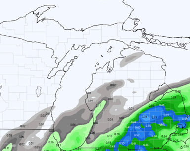
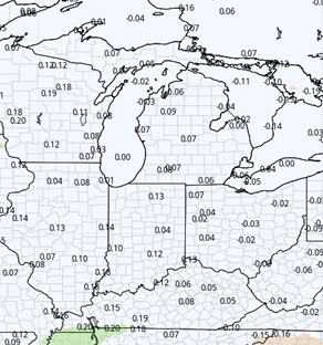
Scattered showers can be expected in parts of the state from overnight Sunday through Monday. However, we are keeping rain potential south of a line from Bad Axe to Berrien Springs. South of that line we can look for a few hundredths to half an inch with 70% coverage. North of that line we see clouds only, and the farther north you go, the fewer clouds we end up with. This will put a slight pause into harvest for Monday morning and midday, but by Monday afternoon moisture is out of here and clouds will break up overnight. The map below shows precipitation potential from sunset Sunday through Monday early afternoon.
We are dry the rest of the week. Sunshine returns Tuesday, and we are sunny, mild and dry right on through early next week. One hiccup we need to watch for will come Saturday overnight. Clouds increase a bit and there may be a slight chance of moisture developing. However right now we feel our atmosphere will be too dry to let anything more than clouds pop up out of that, and that is the reason we are keeping precipitation out of the equation.
A frontal system is developing in the upper Midwest for next Monday the 7th. But we do not expect anything more than a glancing blow late the 7th into early the 8th, and more so in the UP than in lower MI.

Extended Period:
Outside of that potential or rain early in the period on Tuesday the 8th, we look to be mostly dry on through most of the rest of next week. High pressure actually looks to dominate late in the week and for the weekend. This will bring another chance to finish up harvest in a lot of areas.
Weeks 3 & 4:
Mostly near normal precipitation in weeks three and four, meaning we stay on the drier side of things for the overall pattern. Temps will step up a few notches the second half of November and will average 2-5 degrees above normal for the period.
Week 3 Precipitation v. Normal:
Week 3 Temps v. Normal:
Week 4 Precipitation v. Normal:
Week 4 Temps v. Normal: