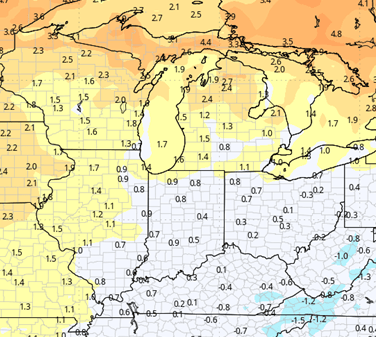

A pattern change is working its way across the Eastern Corn Belt as we move through this weekend. We are going to be seeing a change in temperature in addition to some precipitation. A significant frontal boundary we’ll be Moving across the Corn Belt through the day on Saturday, with a secondary surge coming up the front on Sunday through midday. We continue to see rain totals that can be significant across parts of Indiana and Michigan. The heaviest rains will run on a line, probably from the northern tip of Loert Michigan, back down through a northwest Indiana and into Central IL. In that region, we can see rainfall totals of half to 2 1/2 inches. Outside of that band, we can end up with a quarter to probably 1 inch. The potential for the entire weekend is shown on the map at right. This will be significant rainfall in an area that has not seen much at all over the past few weeks and months. Whether this turns out to be too much is up for some debate, I do think that we can see our best moisture move in quickly due to a dry soil profile, but we cannot really say that there’s not going to be some ponding in some of these higher rainfall total areas. 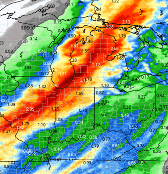
Behind the front we start to clear out quickly through the Sunday night time frame and then we move into Monday with a sunny, warm and dry setup. Winds still out of the southwest. A secondary feature rips through the Great Lakes region on Tuesday, or rather Monday night into Tuesday. This feature can bring scattered showers more so to Michigan than Indiana, but it’s going to be a shift in winds that come behind the frontal boundary that is most important. Rains from this little feature will be anywhere from a tenth to half an inch in Michigan, a few hundredths to a few tenths in the northern third of Indiana, nothing farther South. Temperatures drop off quickly behind this feature Tuesday PM into Wednesday.
![]()
We are chilly and we stay on the cool side of things through the rest of next week. We do not see any significant precipitation coming across in that yoyoing of temperatures Wednesday, Thursday, Friday, but we do see temperatures that are going to be closer to and even a bit below normal. We likely do see some patchy frost, even a freeze or two in that time frame. Next weekend, temperature starts to moderate for the 25th and 26th. We keep that warmer, drier surge on into the start of the week of the 27th. Temperatures will be above normal through close to the end of the month.
Extended Period:
The extended forecast period shows another strong feature developing out in the Great Plains region. A monster low pressure area starts to churn across the Central Plains and pushing moisture up into the Northern Plains and upper Midwest as we head toward the middle of next week. That system will move eastward. I think we’re on track to see it rain move into Indiana, Michigan, Ohio, the Eastern Corn Belt in general as we hit the later part of next week, Thursday the 30th, Friday the 31st, I think we have to keep the door open to some significant rainfall potential. Once again, there is a threat of cool air coming in behind for the following weekend, that first full weekend of November. However, brutal cold is not on the horizon just yet.
Weeks 3 & 4:
For the first time all season, we see temperatures and precipitation over weeks 3 and 4 go back to near normal levels. Week 3 precipitation does really feed off of the bump in moisture toward the end of Week 2 that we’ve kind of talked about here in our extended. Forecast.
Week 3 Precipitation: 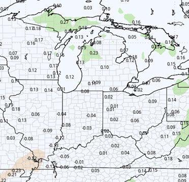
Week 3 Temperature: 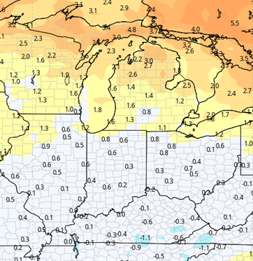
Week 4 Precipitation: 
Week 4 Temperature: