We continue to have quite the challenge ahead of us for harvest the next 10 days. After a soggy week this past week, we start the weekend off with additional moisture for Saturday. Most of it will be in the southern third to southwest quadrant of lower MI, but clouds will be seen in plenty of other areas. Rain totals in in lower MI will be from a few hundredths to .4” with coverage at 40%, but we clearly are not drying any. Much colder air blasts in over the finish of the weekend on Sunday. Strong north winds over the Great Lakes mean clouds will hold firm for most of Sunday and evaporation remains slow.
Monday will be warmer with some sun, and there can be some drying. However, Monday evening scattered showers return with rain totals of a few hundreds to half an inch over 60% of lower Michigan. Those showers linger into Tuesday morning. Then by Tuesday afternoon, another batch of showers moves in along a warm frontal boundary. Rains from Tuesday afternoon through Wednesday afternoon will range from .25”-.75” with coverage at 80% of the state.
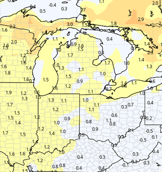
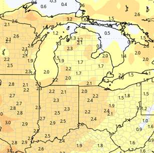
We are precipitation free Wednesday evening through Thursday, and temps stay mild. Then Friday we have our next system moving in from the NW. This wave triggers showers first in the UP and far northern MI on Friday. Southern parts of lower MI likely make it through the day Friday without rain develop. But overnight Friday night through Saturday, we have showers and storms that can produce .25”-1” with 90% coverage. A pause of a few hours may start Sunday, but then showers return on the backside of that system and an additional half inch of rain can move through lower Michigan with coverage at 70%. If you are keeping track at home, that means out of the next 10 days, we have only 2-3 days (depending on where you are) that we don’t see rain, and there definitely will be limited cutting that can happen. The map below shows cumulative rain potential over the next 10 days. Not pretty.

Extended Period:
The entire extended 11-16 day forecast window is dry on this new look. This will allow us to see a good harvest window from the period right behind that Ohio Valley system on forward. While we will be dry, we will only be seasonal on temps…meaning we are cooler, and drying may be a little slow at the start, depending on what locations see for rain totals this coming Friday-Saturday.
Weeks 3 & 4:
More of the same as we move through weeks 3 and 4. Temps recover to just a bit above normal for the middle of November, but precipitation stays in the normal ranges. That means we continue to see moisture moving through, rather than a longer dry stretch. That five day stretch from Nov 1 to 6 may be the best multi day window we see for the time being.
Week 3
Precipitation (green: above normal, brown: below)
Temperatures (blue: below normal, orange: above)
Week 4
Precipitation (green: above normal, brown: below)
Temperatures (blue: below normal, orange: above)