Scattered moisture will be working its way through our region this weekend and the first half of this upcoming week. The Saturday-Sunday timeframe puts together a general “light” precipitation outlook. Saturday showers and thunderstorms are going to be covering about 50 to 60% of Indiana, mostly 30% or less of southern Lower Michigan. For Sunday, we are largely dry both in Michigan and Indiana. However, we cannot necessarily rule out ALL moisture on Sunday. The best chance will likely set up in southern parts of Indiana while Michigan escapes with nothing, at least past mid-morning.
![]()
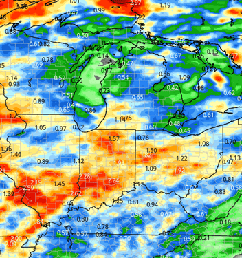
A significant frontal boundary is starting to develop to our west on Sunday, mostly in Minnesota, Iowa and Wisconsin. That system moves eastward for Monday, Tuesday and early Wednesday. A large part of the associated moisture will be ahead of the actual front, sweeping northeast across the region with strong southwests flow This will be warm flow, and that warmer air may enhance thunderstorm potential. It will take a good bit of time for the actual frontal boundary to sweep through the entire Great Lakes region. This means we have to deal with rain and thunderstorms Monday and Tuesday off and on. Monday’s rain should feature more coverage in Indiana than Michigan (70% to 30%) Tuesday we see rain and thunderstorms throughout the entire region, nearly 100% coverage for the day in both Michigan and Indiana. The cold front actually clears through the entire eastern Corn Belt overnight Tuesday night through Wednesday morning. By midday Wednesday, we should be precipitation free over the entirety of the Great Lakes, Indiana and Illinois. Combined rain totals from Saturday through Wednesday morning will likely turn out to be .5”-2” for Indiana, but .25”-1.25” over Michigan. The map at right shows rain potential for today through sunrise Wednesday.
Behind that weather system we see a change to a drier pattern. When it truly kicks off, though, is still a bit up in the air. Lets go to the heart of the matter. For Memorial Day forward, we are seeing strong upper level high pressure park right on top of the Great Lakes. That will give us a high pressure dome that blocks all precipitation from coming through, likely from Memorial Day right on through the 29th or 30th. The uncertainty comes ahead of the dome settling in. The stretch from Wednesday afternoon through Memorial Day has a mostly dry setup for Wednesday afternoon through Friday. There is moisture around east of the Mississippi, but nothing that really wants to dominate IN or MI those days. The days that we really have to watch will be probably Saturday and/or Sunday the 23rd/24th. That’s where we see a little bit of moisture, mostly south of the Ohio River trying to lift north. This concern is mainly for Indiana, and mostly central Indiana if we want to really drill down. In Michigan, the hiccup is moisture trying to move in for Saturday the 23rd out of WI. Like earlier in this forecast, the moisture breaks up, but not completely. Meaning we have potential for 50% coverage of showers through Sunday Morning. . If we can miss moisture on those “wild card”days, we should be in a good position to really take advantage of the dry weather projected by that high pressure dome.
Extended Period:
As the high pressure starts to break down closer to the turn of the month, we will see a little bit more moisture try and sneak in. Later, the 30th through the 1st we can see some scattered showers pop up across Indiana and southern Lower Michigan. Coverage may end up being only about 50 to 60%, but we definitely cannot rule out moisture in that time frame. Temperatures will remain near normal.
Weeks 3 & 4:
Near to a bit above normal temperatures for weeks 3 and 4 (especially week 3). While precipitation looks to be near to below normal for week 3 and near normal for week 4. No major storylines developing in the far extended period at this point.
Week 3 Precipitation: 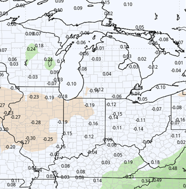
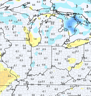
Week 3 Temperature: 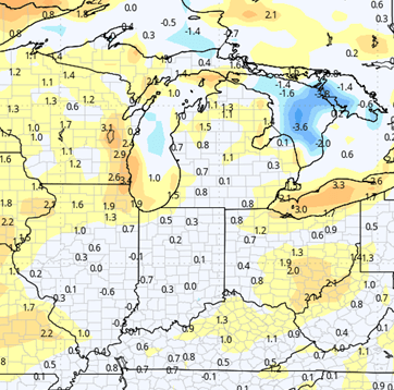
Week 4 Precipitation: 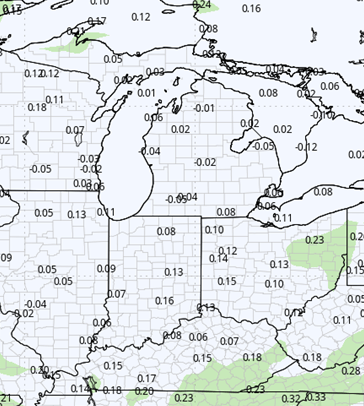
Week 4 Temperature: