
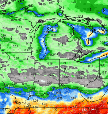
Dry weather for this weekend, but we do see a little bit of a back and forth in our next 10 days. We are working into a pattern that is a little bit drier than recent history, but we are also going to be seeing a slight chance of rain in the southern part of the eastern Corn Belt. Other locations in central and northern parts of the corn belt get away with very limited action in the nearby. The map at right shows a fairly limited area for delay-triggering precipitation over the next 10 days.
This weekend, Saturday and Sunday are sunny and dry in all parts of the region. Michigan, Indiana, Ohio, and Illinois included. Temperatures are going to be slowly but surely gaining a few degrees over the course of this weekend and right on through Monday. Expect them to be seasonal, but not exceptionally warm in that period.
![]()
A significant storm complex in the central and southern Plains this weekend will kick out to the east to overnight Sunday night and to start the week. This will bring some significant rains into the Tennessee Valley and up into southern parts of the Ohio Valley. That surge will likely throw clouds up into southern parts of Indiana, but farther north in northern Indiana and Michigan we continue to roll on with no major weather issues through Monday night and Tuesday. Over the southern third of Indiana we are projecting .25”-.75” rain potential with 60% coverage. Clouds (but no rain) will try to dominate up to about I-70 . Again, farther north we turn out partly to mostly sunny and dry for both Monday and Tuesday.
 At midweek we start to see a few changes. The system to the south drifts away, but as it does, it also is able to tap into a small surface trough to our NW, holding back some colder air. This will allow that Canadian air mass to slide southeast later Wednesday afternoon, and park over the Great Lakes in general through the rest of the week. This will push temperatures back to near and below normal levels. We also are will see northwest winds kick up rather dramatically across the Great Lakes. Those strong northwest winds bring back lake effect cloud cover in MI and the northern half of Indiana. In Michigan we will see the return of lake effect rain showers and at the least a few spits and sprinkles especially near the lake shores for the second half of this week. High pressure builds in toward the weekend with subsiding wind. While better sunshine is likely, we probably cant warm right away as we move into the first weekend in November. We do expect to be drier over all of Michigan and Indiana from late this upcoming week on through November 1-2. The first full week of November will reverse course again, with an opportunity for a huge warm up to start the week, followed by some changes.
Extended Period:
Those changes for the extended forecast window start to kick in right at the middle of next week. We see a strong but slow moving, sagging frontal boundary coming southward out of Canada. This will drop temperatures rather significantly the 5th through the 7th at least. Not a lot of precipitation expected with this slow sagging front, but we won’t rule out a few hit and miss scattered showers probably toward the Thursday, Friday time frame. The certain part of the forecast is the cold air surge. Temperatures should turn out to be below normal and if you have not seen, hard freeze yet (there are some of you that haven’t), that’s when it will be coming – 6th-7th-8th. Now longer term, going into the start of the second full week of November, we look for temperatures to try and bounce ever so slightly.
Weeks 3 & 4:
Week three precipitation looks to be near to slightly below normal, while week 4 starts to see an increase in moisture at normal to slightly above. Temps are cooler in week 3, but still a bit above normal before a significant warm up heading toward thanksgiving in week four.
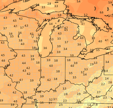
Week 3 Precipitation: 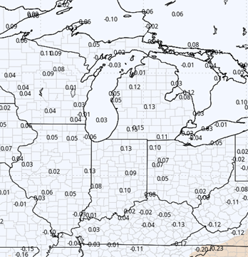
Week 3 Temperature: 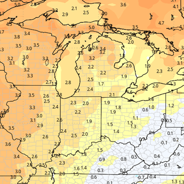
Week 4 Precipitation: 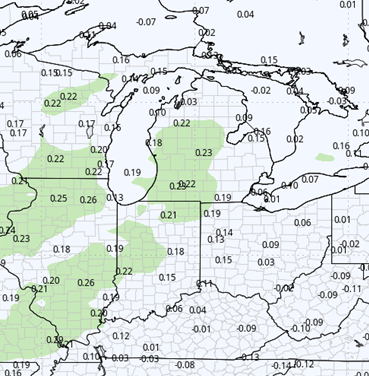
Week 4 Temperature: