
A dry weekend is in store for a large part of the eastern corn belt and this includes Michigan, Indiana and Ohio. We are seeing a strong area of high pressure wanting to build in over the Great Lakes region as we move through next week, but before it gets here we are going to deal with a the remains of a minor disturbance exiting the Great Lakes. We started to see this work through the Great Lakes region late Friday and Friday overnight, giving a few hit and miss scattered showers across Michigan along with cloud cover that down into northern Indiana. However, as we move toward the midday and afternoon hours Saturday most of this moisture will exit quickly, replaced by full sunshine and southwest flow. We will see that dry pattern hold through most of this upcoming week, at least through Thursday. Temperatures will be well above normal, but not quite as warm as what we saw last week before last Wednesday’s frontal passage. The main takeaway here is that we see no formidable precipitation over the next five to seven days from midday Saturday on in any parts of the region.
![]()
As we get into the later stages of next week on Friday another minor disturbance tries to move through the Great Lakes area. This disturbance may trigger some on again off again showers, looking at totals anywhere from a few hundreds to maybe half an inch. Coverage will end up being right around 60% of Michigan, and we can’t rule out a little bit of moisture from I-70 N in Indiana. However, south of the IN/MI line, we are only really looking at a few hundredths to a tenth or two with coverage under 30%. Right behind fast moving wave, we go back to dry weather for the weekend of the 17th and 18th.
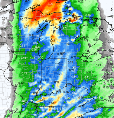
A frontal boundary will be gearing up to our W as we move through the later stages of next weekend. This front looks well organized and should it hold together, can bring some good rains for Monday into Tuesday (20th into early the 21st). Right now, we are projecting rain totals at anywhere from .25”-1”, with coverage at 100% of Indiana and 80% of Michigan. What this will do is actually give us our first really good chance of region-wide rain in some time. However, we are concerned about this falling apart as we get closer to the event. That’s what happened with the last significant front that tried to move through it ended up giving good rains in southern Indiana and leaving a lot of folks disappointed in central to northern parts of the Indiana, acceptable totals in southern lower MI, but disappointment again farther north in MI. The map at right shows an early look at potential for that system from late the 19th through early the 21st.
Extended Period:
The second-half of next week is going to turn off cooler overall. The frontal boundary that moves through early in the week that should bring rain will not bring immediate temperature. We are looking to stay well above normal on temperatures likely through sunset on Tuesday. Then we have a slow moving, sagging cold front that drops through not just the Great Lakes, but the entirety of the northern United States, bringing cold air down close to I-70 or even the Ohio and Missouri River valleys. This cool air will linger through the end of next week Wednesday-Thursday-Friday. Behind it we start to moderate for the weekend of the 25th and 26th and early the week of the 27th, but we are not looking at temperatures rebounding quite as high as where they are currently.
Weeks 3 & 4:
Weeks three and four turn out very similar to recent forecasts. Temps will stay above normal by a handy little bit. But remember, normal are falling steadily this time of year, so cooler temps vs prior weeks are on the way. Precipitation remains near to well below normal.
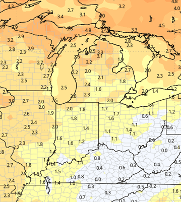
Week 3 Precipitation: 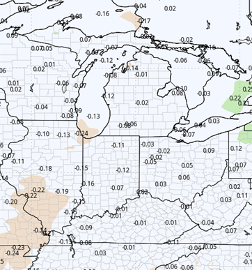
Week 3 Temperature: 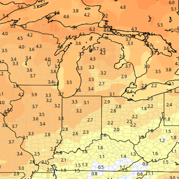
Week 4 Precipitation: 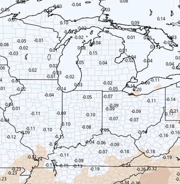
Week 4 Temperature: