
A relatively easy forecast discussion this week. We are going to be working into a significant area of dryness over the next two weeks and that should throw open wide the window for harvest activity period.
Now, as we move through this first week, temperatures are going to be very, very similar to summer as we are above normal highs running from the upper 70s to the lower and middle 80s low relative humidity and fast drying. As we move into the second stage of this two-week forecast we are going to see temperatures try and pull back a little bit, but I don’t think that we get into any below normal temperature profiles at all over the next 10 days to two weeks.
![]()
For the weekend through next weekend, we are going to be seeing full sunshine with winds out of the West and southwest – probably not too strong – but we are going to be seeing this aid our drying profile. We do expect temperatures to pull back just a little bit as we get toward the end of this week but still average a good 10° above normal. Heading into the weekend we will see a little bit of moisture try and get close to the area as the remains – or an offshoot – of one of the tropical systems in the Atlantic try and move through the Carolinas and perhaps back across the Appalachian mountain chain. However, the main area of concern for any kind of offshoot of that is going to be Eastern Kentucky southern Ohio in West Virginia period perhaps far southeastern Indiana can see a few clouds out of that but nowhere else over the state of Michigan over Indiana we’ll see any kind of impact.
As we move into next week, we are going to be seeing a significant push of cool air start in Canada and push down into the Great Lakes region for Monday Tuesday Wednesday we see no significant concern on moisture just maybe some on again off again clouds.
Extended Period:
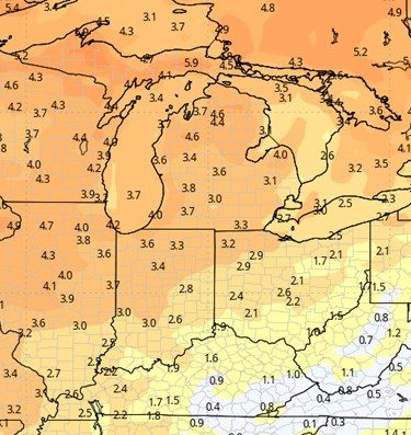
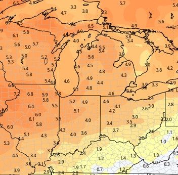
Thursday and Friday of next week to start off the extended 11-16 day forecast window, we probably have to keep the door open to a few hit and misses scattered showers in central to eastern Michigan with less than 30% coverage, but nothing going on down farther west and southwest in MI, along with Indiana. This is what will be responsible for most of the moisture that you see on the 15 day cumulative map at right. The opinion here is that we do not see any significant, well organized frontal boundary coming through until we get closer to the 9th 10th and 11th. That front may have a little bit of moisture, but what it really does is usher in that cooler Canadian air that we talk about pooling just to the north. We look for our temperatures to get back down to near normal and maybe even a slight bit below normal (far north) as we get ready to move into week 3.
![]()
Weeks 3 & 4:
Well below normal precipitation potential still in week 3, getting closer to normal in week for. Well above normal temps easily through the entirety of October (weeks 3 & 4 with nearby too).
Week 3 Precipitation:
Week 3 Temperature:
Week 4 Precipitation: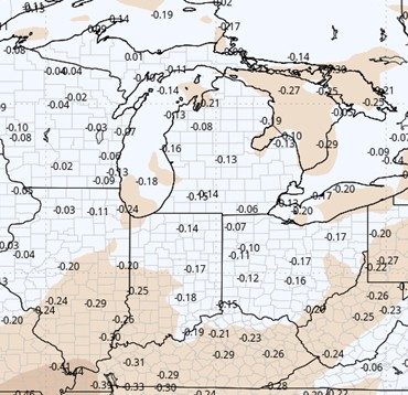
Week 4 Temperature: