
Unsettled weather dominates the eastern corn belt through the first part of this forecast period in our Planting Weather Forecast—presented by Greenstone Farm Credit Services.
Behind the frontal boundary that pushed it through leading into the weekend we’re seeing a little stagnation in the flow pattern across the eastern corn belt. That will lead to some hit and miss scattered showers that pop up across the Hoosier state and not just today but into tomorrow while farther to the north over Michigan we stayed just north of the fray and we actually end up with just some on again off again cloud cover.
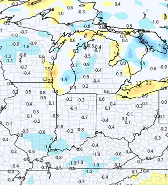
Rains for both Saturday and Sunday in Indiana will be anywhere from a tenth to maybe half an inch with coverage at around a 70% on Saturday maybe backing off to 50% or less on a Sunday while in Michigan outside of maybe a spit or sprinkle in the Southern Tier counties we end up with nothing. The low pressure that’s at the center of these waves of moisture coming through will actually slow dramatically low pressure that is at the center of this complex that’s trying to move through we’ll slow very dramatically as it moves off to the northeast going into the first part of next week.
We end up with backside, wrap around precipitation that may pop up over Indiana and Ohio for Monday and Tuesday but once again nothing super dramatic farther north. In Michigan the only place that we see a little deviation from this thought process may be Sunday the wave that comes north and interacts with some backside wrap around moisture may throw some scattered showers into the state South of I-94 or at most up to I-96 however it does not look like it’s going to be a significant batch of moisture nothing that knocks us out of the field long term.
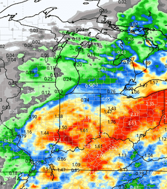
Altogether between Saturday and Tuesday, Indiana can see anywhere from a tenth to maybe 3/4 of an inch of combined precipitation while southern and Michigan may end up with a few hundreds to 1/4 which maximum central and northern Michigan will be precipitation free.
The map below shows combined precipitation potential for Saturday through Tuesday evening.
From midweek forward next week, we definitely are moving back into a drier pattern. We are going to be seeing a significant surge in temperatures for the Wednesday through Saturday time frame temperatures getting back closer to normal and even a bit above.
Evaporation should be significant and dried down fast which means with any luck those of you that are on the lower end of precipitation over the next few days should be able to get right back into the fields fairly quickly anybody that picks up higher precipitation is going to be back in by late week and the weekend.
Going into the week following we are going to be seeing a continuation of the dry pattern this is going to continue to create good evaporation rates near maximum of 1/4 to 1/3 of an inch of precipitation or moisture per day combine that with strong west and southwest breezes and dryness is going to be the key to start off the week of the 12th.
Extended Period:
The week of the 12th we should end up seeing significant dry down potential the only fly in the ointment so to speak is going to be a little bit of pop up shower and thunderstorm activity mostly due to heat based instability. Temperatures are going to be above normal for this time of year but we aren’t going to be seeing excessive heat just yet it will just be enough to create a little instability. Toward the end of the week getting closer to the 18th and 19th we are going to be seeing a little bit of activity start to build in the western United States, and so we have to keep an eye out as we move into the following week although right now we are not seeing excessive rains at all.
Weeks 3 & 4:
For precipitation, week 3 looks to be near normal. Week four starts to slide more wet as we see slight influx in scattered shower action after the Memorial Day holiday with us getting ready to flip that calendar over into the 1st of June. However on temperature we’re just not really seeing anything too exciting.
Near normal temperatures for the last week of may into early June (week 4) and then we end up with temperatures near to slightly below normal for week 3 overall once again. It’s not a major problem, as we continue to see temperatures warm enough to promote good growth and development coming out of the ground.
Week 3
Precipitation (green: above normal, brown: below)
Temperatures (blue: below normal, orange: above)
Week 4
Precipitation (green: above normal, brown: below)
Temperatures (blue: below normal, orange: above)