
After a largely dry week this past week, we will be dealing with a bit of precipitation over the Holiday weekend. Scattered showers Friday night through Saturday midday will put down anywhere from a few hundredths to half an inch but will only have coverage of 60% of the state or less. We should get sunshine for the later afternoon Saturday, and clear out overnight Saturday night.
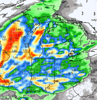
Sunday starts with sun, but then a significant storm complex moves toward the state. We will have showers and thunderstorms Sunday afternoon through Memorial Day early morning. Rain totals can be 0.25”-1.5” with coverage at 100% of the Region. The map below shows this event, as it will be the most significant one of the entire 10-day period.
Memorial Day does turn out to be pretty decent, though. Rains end early morning, then clouds give way to sun. We expect evaporation rates to improve quickly. Tuesday there is a round of scattered showers that moves through Michigan, and that may throw clouds into northern Indiana. In addition, we can’t rule out a renegade shower or two in far northern tier counties that border Michigan, although we don’t think this really is a big possibility.
The rest of the state is dry. In fact, we are dry from Monday afternoon through next Sunday over the entire state. Fantastic drying is expected, warm temperatures and this should give us the window of opportunity to get the remaining fieldwork done in most instances. How fast we get back at it will all depend on what we see for rain totals from this Sunday afternoon-early Memorial Day event.
A frontal boundary is ready to move through right at the end of the 10-day forecast window overnight next Sunday the 2nd into Monday the third, but likely will have only half an inch or less on 70% coverage.
Extended Period:
After that front moves through to start the week, we should be dry for Tuesday and Wednesday. A system is slated for June 6th (Thursday) that can bring rain and thunderstorms to the entire region on the order of .1”-1”. Showers can linger in the wrap around of a large upper level low for Friday, Saturday and Sunday, adding another .75” over the 3 extra days combined.
Weeks 3 & 4:
We expect normal to below normal precipitation in weeks three and four. Temps look to be normal to slightly below for week 3, but warm dramatically in week 4, moving to a good 2-3 degrees above average for the 3rd week of June.