
A damp start to the forecast period is here for Saturday, as a minor disturbance moved out of the Upper Midwest and into the Great Lakes last night. Scattered showers will be here into mid afternoon, and we can see a few hundredths to half an inch with 80% coverage. No drying for Saturday. Sunday expect a mix of clouds and sun, with scattered showers developing again late Sunday afternoon and evening, this time in the UP and northern tier counties of lower MI. Rain expectations are for a few hundredths to a few tenths.
We have to leave a few showers in the forecast from I-94 south for later Monday afternoon into Tuesday, but generally the early week system for the eastern corn belt stays south of most of MI. As such, we should put together net drying in all other areas from Sunday late afternoon forward through Thursday. The drying settles in Tuesday afternoon in far southern lower MI.
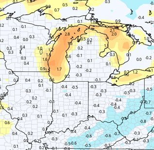
The most significant threat of rain in the next 10 days comes late next Friday night through Sunday morning. We can see a couple of waves of showers in that period that bring combined rains of .25”-1.25” with coverage at 70% of the state. The best rain totals will be in central and southern lower MI, but we won’t rule out moisture anywhere.
Behind that system, we dry down for next Sunday afternoon, and should stay dry into the start of the extended period. The map below shows 10 day combined rain potential for the state of MI.
Extended Period:
The week of the 20th looks mostly dry over a large part of the country. There is a minor area of low pressure developing Monday the 20th in southern Montana and the western Dakotas. However, it does not have much moisture with it, and we should see action stay mostly clear of the region. If it does hold together all the way into the corn belt, we will likely see a few showers Tuesday the 21st, but other than that, we have no serious threat of rain. Even that threat we have low confidence in developing, meaning we might just string together our first longer term dry window of the planting season so far.
Weeks 3 & 4:
Weeks three and four both look to be near normal, meaning we see at least one chance of rain in each 7 day period. Week 3 is cooler than normal, but week four should return to near and slightly above normal levels.
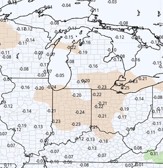
Week 3 Precipitation (Green = above normal, Brown = below)
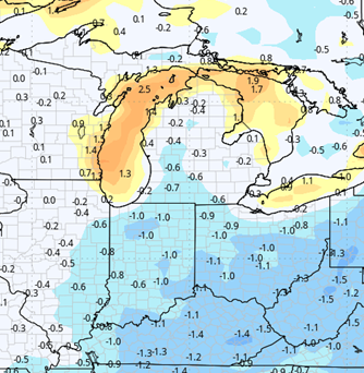
Week 3 Temperatures (yellow/orange = above normal, blue = below)
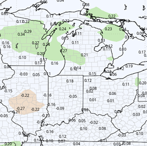
Week 4 Precipitation (Green = above normal, Brown = below)
Week 4 Temperatures (yellow/orange = above normal, blue = below)