

Dry for the most part over the next week or so. We are going to see cool air dominate for this weekend as strong West and northwest flow is in control for Saturday and early Sunday. Winds start to turn to the West and the southwest to Sunday afternoon which should start to bring warmer air in for next week. The northwest flow through a large part of the weekend will keep some lake effect cloud cover top of mind. However, the best areas of cloud cover will be in Michigan and just the far north to northwest tip of Indiana. In these lake effect clouds, we can’t rule out a few spits and sprinkles very, very close to the Lake MI shoreline, but we do not it to be any more widespread than that.
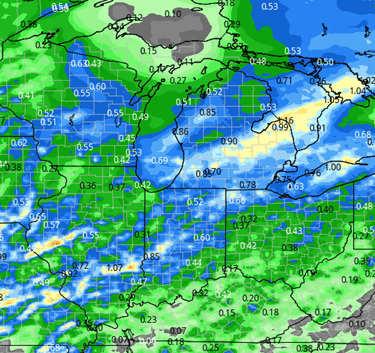
Once we get into next week, we do start to put together a warmer surge. We are completely sunny and completely dry Monday through Friday morning. Temperatures should be seasonal to just a bit above normal throughout the period and winds will be present but not nearly as gusty as this past week. Our next frontal boundary that we have to pay attention to shows up late in the week. Friday afternoon, clouds build, and we have to watch for a few hit and miss scattered showers trying to come across the region Friday night through Saturday. Right now, we’re looking at anywhere from a tenth to maybe 3/4 of an inch with coverage at around 80% of Indiana. And we can see anywhere from .25”-1” of precipitation across Michigan coverage at 75%. This will be the first wave. Then we see a second minor system for Sunday that can bring a few spits and sprinkles. This time, more in Indiana than Michigan. The map at right shows precipitation expectations for the event through the weekend. Monday sets up to be dry to start next week, perhaps a bit cooler before a partly to mostly sunny start to Tuesday. Clouds increase Tuesday afternoon, and we get ready to get a little bit more moisture in the forecast as we move into the extended forecast window.
![]()

Extended Period:
A nice front sweeps through the entire Eastern Corn Belt overnight next Tuesday night the 11th into Wednesday the 12th. Currently we are expecting 100% coverage across both Michigan and Indiana, but totals are not all that impressive, at a tenth to maybe half an inch. That front moves through relatively quickly, and we dry down behind for Wednesday afternoon. The rest of the week is much warmer, and we see strong SW wind dominating. Thos strong winds are ahead of a powerful system developing in the plains that will move through the eastern corn belt from Friday the 14th through the weekend. That system is in 2 stages. The cold front is strong and triggers showers and storms for Friday the 14th. 100% coverage over both MI and IN. Stage 2 is the lagging upper-level low that tracks out of the Upper Midwest and into the Great Lakes for the weekend of the 15th and 16th. That low will bring cold air racing down out of Canada, plenty of clouds and lingering hit and miss showers for all areas, but more so MI than Indiana. Rains from the frontal passage can be .25”-1.5” and then the drawn-out weekend stuff will yield another few hundredths to at most .4”. This low can reset the temperature pattern moving into weeks 3 and 4.
Weeks 3 & 4:
Week 3 precipitation is above normal by just a bit, while week 4 looks normal. Temps will have an above normal tail for week three as the pattern begins to change and will be near normal in week 4.
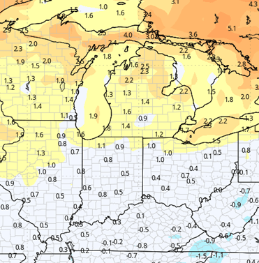
Week 3 Precipitation: 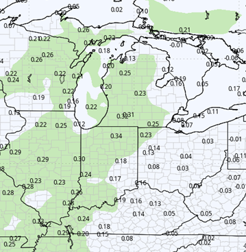
Week 3 Temperature: 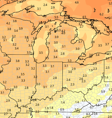
Week 4 Precipitation: 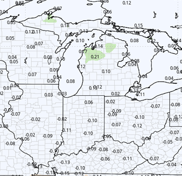
Week 4 Temperature: