


Drier weather is unfolding as we move through this weekend in the Planting Weather Forecast presented by Greenstone Farm Credit Services.
High pressure is going to be setting up shop over the Great Lakes region and that should give dry weather to all of Michigan and Indiana. The entire eastern corn belt falls into that kind of pattern.
We are going to be looking at sunshine trying to make a good comeback over the area, but also we’re likely going to end up with cool temperatures holding just a while longer, thanks to that high pressure dome. Sunshine should take control for Saturday and for Sunday. Temperatures are quite chilly to start off the Saturday time frame, but we’re also going to see winds turn from the north back around to the west and southwest as we get into the start of this upcoming week.
Memorial Day will also be dry, and temperatures will start to climb. A new wrinkle in the forecast that started to develop late this past week as a fairly significant weather complex that’s out in the central plains is expanding as it moves eastward. This means we have to watch for a little bit of precipitation trying to nose into a southern Indiana probably later Tuesday afternoon and Tuesday evening and that moisture may spread farther north as we get into the overnight Tuesday night and Wednesday morning period. Right now, we’re expecting a rainfall totals in southern Indiana let’s just say I-70 southward to likely be anywhere from 1/4 to 3/4 of an inch.
Then, as we move through the overnight period and into early Wednesday, I can’t rule out anything from a few hundredths to maybe half an inch in areas in the northern part of Indiana and into far southern lower Michigan. Coverage at this point likely end up at about 60% or less in Indiana, and 30% in MI. I don’t necessarily like this solution, but I cannot argue with the fact that:
- A) weather events in the central plains are not going away, and
- B) are expanding in their geographic coverage so that means we have to watch for some of this moisture to try and towards us.
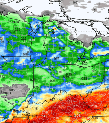
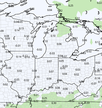
The Wednesday-Thursday time frame also looks a little bit unsettled. I can’t rule out so few pop-up scattered showers across the Hoosier State. However, I don’t think they are incredibly spectacular. That instability may be a little more impressive into Michigan which will allow for some spotty action here and there. The map below shows rain totals Monday night through Friday morning.
We finish the week next week, Friday, Saturday, and Sunday with mostly dry air. Strong upper level high pressure takes control with a nice ridge building in. That will actually allow us to see some warmer air take full control. We could actually be above normal on temperatures for next weekend that also plays into our next frontal boundary that likely shows up as we get into the first full week of June.
![]()

Extended Period:
The extended 11 to 16 day forecast window gives us a shot at moisture late Tuesday into a Wednesday we’re talking mostly the second third and perhaps the early 4th. At this point we’re looking at a minor front sagging through the area that can give anywhere from a tenth to maybe 3/4 of an inch coverage around 75% of the region both Indiana and Michigan. Right now I don’t think there’s a significant rain threat in there but what we are seeing in that first full week of June is a shift to a pattern that may not necessarily lead to long term drying but just some timely light precipitation. Temperatures stay above normal.
Weeks 3 & 4:
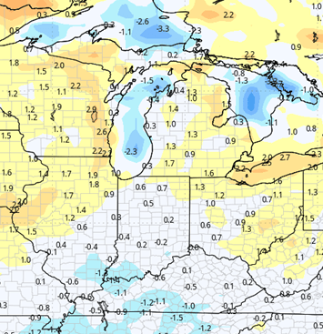
Precipitation stays near normal in week 3, but bumps up with a bit more activity in week 4 to be slightly above normal. Temps show a wide spread both weeks, but especially in week 3. WE are quite warm to the north over MI and the Great Lakes, but in the OH valley we end up cooler than normal. The difference in airmass eases some in week 4, but still is showing tendency to have warmer air holding over MI vs. IN.
Week 3
Precipitation (green: above normal, brown: below)
Temperatures (blue: below normal, orange: above)
Week 4
Precipitation (green: above normal, brown: below)
Temperatures (blue: below normal, orange: above)