


We have a very dry start to this forecast as we move through the weekend in our Planting Weather Forecast presented by Greenstone Farm Credit Services.
Sunshine will dominate for both Saturday and for Sunday and we should see temperatures very pleasant. Honestly, temperatures will be a little bit below normal for this time of year, but with the sunshine and some decent west to northwest breezes, we should end up seeing fast drying and high evaporation rates.
This pattern continues into the start of this coming week Monday turns out partly sunny, but clouds will be increasing as we move through the afternoon.
A significant low pressure area will be developing in the Great Plains to finish the weekend with lows strung out from southeastern parts of Montana across Kansas and ending up down in eastern Oklahoma to western Arkansas. This is going to be slowly but surely moving towards us, and as it does, so do scattered showers and clouds start to build into Indiana on Monday afternoon and evening. The only place that we see precipitation of any kind of size will be in southwestern parts of the state on Monday. The rest of the region will see our precipitation build on it Tuesday.
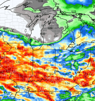
From Tuesday through Wednesday we expect multiple rounds of strong showers and thunderstorms in Indiana, Ohio and southern lower MI. In Michigan, the upper bound of the moisture will be around I-96. This moisture will be significant in that it runs anywhere from 1/2 to two inches coverage at around 80 to 90% of IN, OH and lower MI. Some thunderstorms can be strong to severe, but the best chance of those will be Tuesday night into early Wednesday.
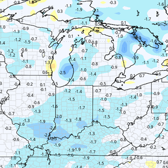
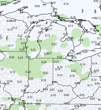
Central and northern Michigan will be dry for the entire week. Moisture may linger into the start of Thursday in the south but not for very long. Clouds will give way to some sunshine on Thursday and that leads to a dry finish to the week. The map below shows precipitation potential for the week next week.
Friday into the Memorial Day holiday weekend we should see partly to mostly sunny skies, and we believe that we can stay on the drier side. There is a little bit of instability trying to develop to the West, but it is not a major player at this point in time. What we do see is temperatures climbing through the Saturday-Sunday-Monday time frame with us being above normal by the time we get to Memorial Day.
![]()

Extended Period:
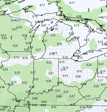
For the extended 11-to-16 day forecast window, we end up being unsettled while we continue to see decent warm there and some sunshine we also are expecting some heat based thunderstorms to develop. The best chance of these will be coming in late Tuesday afternoon into Wednesday and then again later on in the week toward Friday. Moisture totals don’t look overly impressive out of that batch of moisture, but we are going to be seeing probably a tenth to half an inch each time coverage at around 70% by the time we get into the start of June. We should be looking at drier weather trying to emerge, but heat-based thunderstorms may continue to be part of the discussion.
Weeks 3 & 4:
Precipitation bumps up in weeks 3 and 4 with us trending a bit above normal. Temps will stay near normal, but slightly warmer in week 4.
Week 3
Precipitation (green: above normal, brown: below)
Temperatures (blue: below normal, orange: above)
Week 4
Precipitation (green: above normal, brown: below)
Temperatures (blue: below normal, orange: above)