


Sunny and dry weather dominate the landscape through this weekend and into early next week in our Planting Weather Forecast presented by Greenstone Farm Credit Services.
As we move forward, we are going to be seeing a chance of moisture coming together as we move through the middle part of next week, but we are honestly a little ways away from a dominant moisture pattern coming back to the Great Lakes and eastern corn belt in general.
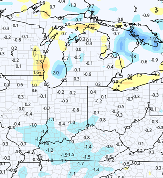
Nearby we expect temperatures to be warming through the weekend and Monday we should be above normal by the time we get to Saturday afternoon or Sunday morning and we are also going to be seeing it decent southwest flow wins coming in to help dry. Evaporation rates will be at nearly a maximum over the region and we should see soil profiles that dry down significantly, even in areas that saw significant rains that just a week or so ago.
Once we get to Tuesday, we are going to have to watch for the remains of a system that has been slowly meandering through the Deep South to try and come north. This will first bring lots of clouds into Indiana from Tuesday morning to midday, but we also will not be able to completely rule out a few hit and misses scattered showers. The best chance of this precipitation, will end up being in central and southern Indiana but still we would be remiss if we took it out of any northern tier counties.
Overnight Tuesday night and Wednesday, we can see better potential in the southern third of lower MI. All in, all done I don’t think we’re looking at anymore than a few hundreds to maybe a few tenths in most places, but we are definitely not going to be doing much drying on Tuesday.
The balance of Wednesday it seems like we want to have some clouds linger all the way through the Great Lakes and eastern corn belt. In those clouds we could see an additional batch of spits and sprinkles. We don’t think it amounts to a lot of precipitation but once again it means we’re not going back to hardcore drying for Indiana.
Next Thursday is dry. We are seeing temperatures moderate once again and the return of some humidity. As we move into the Friday-Saturday-Sunday time frame, we are generally a little more unsettled, and that will lead to some hit and miss pop up thunderstorm activity.
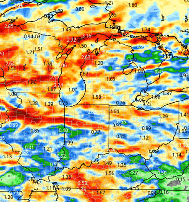
On Friday, we think that’s mostly going to be a South and east, but for Saturday we’re going to be seeing clouds increase and a stronger frontal complex tries to develop for Sunday. This will put rain potential all the way from the UP/Canada down through the OH river. That system takes control of the region late Sunday afternoon and we will see rain likely through Monday the 19th and potentially into early Tuesday the 20th. Rain totals from that system will likely end up in 1/2 to 1 1/2 inch range maybe even with some stronger thunderstorm activity.
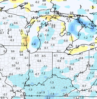
The map below shows precipitation for late week into through next Tuesday.
Extended Period:
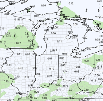
For the extended 11 to 16 day forecast window we are going to be a little more active after the rains get done Monday the 19th into Tuesday the 20th. We’ll likely just see some lingering cloud cover off and on and the potential for some near term at drying. However by the end of next week we are seeing another follow complex trying to work in which could bring another half to 1 inch of a precipitation across most of the state, I’m looking at at least 75%.
The Memorial day weekend has a bit of dryness, but we still are seeing at least 1 threat of moisture before we exit Memorial Day itself.
![]()

Weeks 3 & 4:
Precipitation in weeks 3 and 4 will be near normal. However we are not seeing any major heat. This is important because in the plains this weekend and next week we are seeing temps blowtorch into the 90s. That kind of pattern does not look to spread this way super fast. In fact, temperatures can arguably be just a touch below normal, although we are saying near normal for now.
Week 3
Precipitation (green: above normal, brown: below)
Temperatures (blue: below normal, orange: above)
Week 4
Precipitation (green: above normal, brown: below)
Temperatures (blue: below normal, orange: above)