
Harvest gets a little more challenging in this forecast, as we are seeing slower drying and pesky clouds on the horizon, as well as another strong system this coming week.
The weekend will feature plenty of clouds as a strong upper level low moves across the Great Lakes. We have clouds and scattered showers rotation around that low for the weekend, with the bigger shower threat coming Saturday, but clouds holding over the region all weekend long. Strong north flow will also be bringing down very cool air, and we will be well below normal over the entire state all weekend. Clouds will keep us from talking about frost too much in lower MI. Clouds continue to rotate through as the low moves farther east Monday and Tuesday, and we can’t rule out scattered showers either, but those days precipitation will likely be a bit farther north, over the northern half of Lower MI and the UP. Any precipitation that falls over the next 3-4 days will be light, but it’s more of an indicator that we will not be drying fast at all during this stretch, and that will slow our potential to return to the fields.
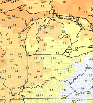
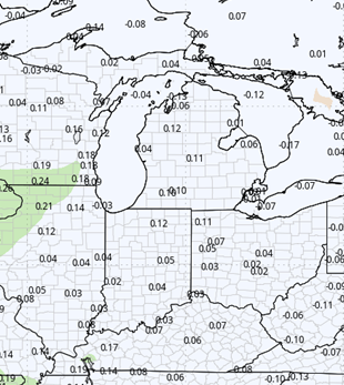
By mid-week, we are finally away from the low, and trying to warm a bit. A warm front will be lifting through the eastern corn belt and will likely trigger showers in Indiana Wednesday afternoon. However, we stay dry here. That front sets up on Thursday near the IN-MI line. Showers can work through the southern half of lower Michigan all day Thursday, while we stay dry farther north. The low that is associated with the warm front ejects out of the plains Friday, racing across the eastern corn belt. Rain and thunderstorms will be here all day Friday into early Saturday morning. Combined rain totals from Thursday through midnight Friday will be .25”-1.5” with coverage at 75% of MI. The best rains will be in the south. The top end of the range will likely be helped by thunderstorm development. The map below shows the late week rain potential.

Behind the system, we turn cooler again with below normal temps for the weekend (14th-15th). Sun returns on Sunday, and Saturday stays pretty cloudy. Dry weather moves in with warmer temps to start the week of the 16th.


Extended Period:
The extended period has our next large scale system arriving for the weekend of the 21st and 22nd, with rain and thunderstorms bringing threat of .5”-1.4” and 80% coverage. That would suggest we have a mostly dry window for the week ahead of that, although with warmer air trying to return, there could be some spotty instability to watch Tuesday-Wednesday. The weekend system does look to move slowly, as the main low is getting close to being cut off from the main steering of the jet stream.
Weeks 3 & 4:
Similar to last week, weeks 3 and 4 are near normal on precipitation, so we can expect at least one good frontal passage each week. Temps will be 2-3 degrees above normal on weekly averages, so the warmth relative to normal continues into early November.
Week 3
Precipitation (green: above normal, brown: below)

Temperatures (blue: below normal, orange: above)

Week 4
Precipitation (green: above normal, brown: below)

Temperatures (blue: below normal, orange: above)